Ulytau nature


If viewed from the point of view of geographic centrography, then Ulytau is the geometric center of our Motherland, the very heart of the Kazakh land. The area of the Ulytau district is 12,293,105 hectares, which is 30% of the area of the Karaganda region and 4.5% of the territory of Kazakhstan, 540 km from west to east and 435 km from north to south.
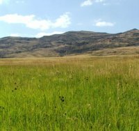
The relief is shallow, low-mountainous, hilly terrain and vast valleys between the hills. Natural zones: steppe, semi-desert and desert. Sharply continental, arid climate, intense evaporation, frequent winds. The maximum air temperature in summer is + 45⁰C, in winter it drops to -46⁰C.
The highest point is Mount Akmeshit Aulie - 1130 m. And Mount Edyge (1060 m); In addition to the Ulytau massif itself, there are also mountains Kishitau, Arganaty and Zheldyadyr. And the lowest point is the Mynbulak lowland, located in the southern part of the Karsakpay hills, about 100 meters above sea level.
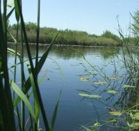
There are 12 rivers, more than one hundred springs and 11 lakes in the Ulytau region. The largest river is Karakengir. The length of the river is 350 kilometers, the washed territory is 16,700 kilometers, the average annual flow reaches 2.1 cubic meters per second. In summer, many reservoirs dry up or shrink in area. Among the many lakes, the largest are Karakoyin, Ashchikol, Barakkol, Koskol. Togai thickets grow along the banks of the river and lakes. According to geographical and botanical studies, 617 species of vegetation were found on the territory of Ulytau - trees, shrubs, semi-shrubs, herbal perennials. Among them, more than two hundred are medicinal plants, 19 of which are considered to be among the rare species. Specialists of the reserve-museum, together with the Zhezkazgan Botanical Garden, carry out research work to study the flora of Ulytau.
The fauna of Ulytau is also rich, here there are animals listed in the Red Book.
Discuss
Similar materials:
Comments (0)


